3 01 2012
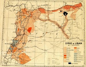
From 1935 Map of ethnic and religious in Syria
Syria and Lebanon. Map of 1935. Religious communities and ethnic groups. Map prepared by the Bureau of Topographical French troops in the Levant. 1 / 200 000th, 73 × 67 cm.
سوريا و لبنان , خارطة تعود للعام 1935 توضح التوزع الديني و الأثني للجماعات في سوريا , تم اعداد الخارطة من قبل القسم الطبوغرافي للقوات الفرنسية في الشرق الأدنى, المقياس المستخدم 1/200.000 بحجم 73*67 سم
الخارطة موجودة في المعهد الفرنسي للشرق الأدنى في بيروت

